Tag Archive: hiking

Review: Hiking around Bishop’s Peak in San Luis Obispo, CA

the trail

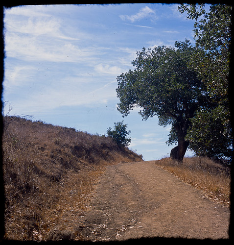
On a sunny late morning in mid September, I set off towards Bishop’s Peak in San Luis Obispo, which is a decent-sized hill/mountain/whatever featuring a number of trails up, down, and around.  Most start off pretty steeply, then either fall off or, if you’re headed to the peak, almost 1800 feet higher in elevation from the trailhead, just keep going up.

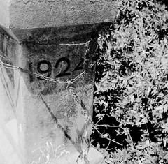
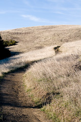
I have not done a lot of steep, sustained hikes lately so I went with a more flat route.  Starting from the Patricia Lane trailhead, I went along Felsman Loop.  This is a bit of up and down, but we’re talking mostly 30 feet from trough to crest so not too hard at all.  Due to time, I cut the loop basically in half by going across the Shady Grove trail, then back down, splitting off to the left when I reached the Cattle Pond to get back to the trailhead.  The pond, by the way, is a dry indentation in the ground.  I wonder when was the last time any cattle actually congregated there.

rock and branchIt’s an easy hike other than the inclines.  Part of the beginning of the loop is even paved, though right after you swing around the Water Tank it feels like you’re trying to circumvent security or something – you’re on a 1′ wide trail that falls off the hill quite steeply to one side, and hugs the fencing on the other.  But indeed it is the trail.

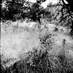
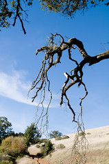
It’s a fairly exposed trail so bring sunscreen and/or a hat, though there are patches of trees that provide some shade.  Overall a nice hike, and one I wish I could have devoted more time to.  I did the loop – Felsman>Shady Grove>Felsman in about 1.5 hours, stopping for pictures along the way.

Review: Hiking at Los Osos Oaks State Preserve (CA Central Coast)

rising from the earth

While visiting my wife at her workplace down in Templeton, in California’s Central Coast region, I took some time to do some hiking.  First stop was the Los Osos Oaks State Preserve, which might actually be in Morro Bay rather than Los Osos.  It’s pretty close, I think.  Quite accessible from the Templeton/Paso Robles/Atascadero area – maybe 30 minutes if you average all three starting points.

I read about the preserve in the Sierra Club’s Trail Guide for San Luis Obispo County.  I was drawn by the description of these 800 year old “dwarf oaks,” which are HUGE and have branches so long and so heavy that they have touched back down to the ground for support, then grown out from there.  path They really are impressive.  It’s described as “mystical” in the book and that’s actually not a bad description.  I went around noon which made it a bit less so, but I can see a morning hike being quite atmospheric.

The hike is also a level one, and relatively short.  Maybe 100 ft in elevation change and about 2 miles, I think, based on the loop I did.  I spent about 2.5 hours there (note: I’m a slow hiker due to stopping constantly for photos).

(more…)

Review: Sweeney Ridge Trail

This past weekend (May 2, to be exact), I went up to Sweeney Ridge for the 2nd time.  It’s kind of a weird “trail” – it’s really a paved road for about 1.5 miles, then I veer off onto…another paved road that leads to a completely abandoned, falling apart (the point of dangerous) old Nike missle radar station.  One can also veer off to a dirt trail that is more hiking-ish that leads towards the point where the bay was first discovered a long time ago (yes, I am very precise, aren’t I?) and most people go there.  But I was after abandoned buildings (link and link, copyright respective photographers)

The paved road for the first part, leading up to the split, is fairly steep, then really steep, then fairly steep again.  It really kills because it just goes up and up for a pretty long time.  The first time I did it, I went straight on up with a full photo backup and I thought I was going to die.  This time, I stopped about 2/3 of the way up long enough to take a large format photograph (so…15-20 minutes) and that was a perfect amount of time for the trail mix to kick in, for my legs to get enough rest, but to not lock up and refuse to move on.  If I had not done that I would have had a serious problem.

Once you reach the top (and this is after you’ve passed the fog line, by the way, and have been walking in the rain for a while), it’s windy as you are completely exposed.  Wind coming right off the ocean is just blasting you from the west.  Pretty intense hike for about 4 miles total.  

Great place for abandoned places photography.  Images to come.  5×7 images…

(Short) Review: Almaden-Quicksilver Park, McAbee Road entrance

1924I am pretty sure I did a review of this trailhead before, but it was lost when the bulk of my blog vanished.  So this is just a short one, since I haven’t been back on this trail in a while now.  I found a roll of film that I shot while on a hike starting out from this trailhead into Alamaden-Quicksilver Park.

I was not particularly impressed by this trailhead, to be honest.  The trail starts off basically as a road, which means lot of joggers, bicyclists, power walkers, etc.  Of course, I have no problem with others that use these parks – none at all.  But it isn’t really a trail for quite some time.  The first photo here is of a post on a little bridge that makes up part of the path.  Again, it’s more than just a trail at the outset.

There are also a barn right when one gets onto the beginning of this trail, with at least one old, rusted out car abandoned there.  It’s not from 1924 – it’s an old VW Beetle.  But it’s still kind of cool. 

Eventually, however, the trail does appear. I don’t know exactly the combination of paths I took, but I know I ended up on the Guadalupe Trail at one point.  This is a relatively flat path but it’s also out in the open, meaning that it’s hot and really tires you out if it’s sunny.  It’s not a particularly scenic route, either, though it has its moments.  

along the trail

This second photo was taken somewhere along the trail.  I believe towards the beginning, before it opens out into the sun.  That part of the hike is pretty well covered, with nice foliage, big trees that hang over the path and provides pretty nice shade.  I am fairly certain this is the Senador Mine trail.  

I might go back just to try and remember what trails I took…

Review: Monte Bello Open Space Preserve

fingersLast weekend, I went on an “exploratory” hike in the Monte Bello Open Space Preserve, which is located between Rancho San Antonio, Skyline Open Space Preserve, and Upper Stevens Creek Park.  It’s basically straight west on Page Mill Road, well past 280 and almost to Skyline.  Windy road, and lots of fun if your car’s suspension can take it.  This park is also part of the Mid-Peninsula Open Space Preserve, which is a large collection of parks in that area.  There is a flickr group for it, though it’s not very active.

I say exploratory because I really was going in for just a short, 4-5 mile hike to see what the place was like.  How shaded, what kind of foliage was there, etc.  I also went relatively late in the day – about 2.5 hours before sunset – so just looking around was about the most I could do.  You can get a PDF map of the park if you want to follow along with my review.

As always, I planned a route and managed to take a different one anyway.  It was not quite the featured hike from the bahiker.com link above, but my goal was to take the Stevens Creek Nature Trail just to the White Oak trail and be back.  That would be only about 3 miles or so.  However, I got a bit waylaid and turned onto the CAnyon trail rather than making the right onto Stevens Creek.  I eventually looped back onto the Stevens Creek Trail and back to the parking lot.

The signage in the park is really quite confusing – I honestly could not figure out which junction I was at most of the time.  I also managed to sprain my ankle when I thought I was about halfway, which made me keep going.  Turns out I was about 1/4 of the way, and should have just turned around…

The park is a very nice place to hike.  Bikes are allowed on many of the trails but no horses for the most part, and it wasn’t very crowded even for a Saturday afternoon.  You walk in and out of tree cover so it’s not a hike exposed to the sun.  Also, Stevens Creek is just a trickle now but apparently moves quite a bit of water in the winter and that all feeds into a great big bloom of wildflowers in the spring.  Even now, in late November, there was decent greenery and some small amount of flowers about.tiny

The trails can be a bit narrow the path often takenas one walks around and you have to make way especially if a bike comes around, but they are more than manageable and in a way it’s part of the park’s charm.  It’s not that crowded (perhaps the windy road dissuades some people) so the trails aren’t huge, nor are there tons of trails that lead off into nowhere.

I will be visiting it again soon.

Review: Calero County Park, Los Cerritos Trail, McKean Rd entrance

This afternoon I decided to try a new park and went to Calero County Park, in San Jose.  It’s about 30 minutes south of my home in Santa Clara to the entrance just a bit past the intersection of McKean and Bailey Roads.  Unlike most of the parks in the area, Calero is equestrian and hiking only – no bikes – which means it’s pretty quiet, and you don’t run into a lot of people whizzing by.  It’s also probably why it’s simply not as crowded, even on a nice Sunday.  Since the quiet is a big part of why I like to go hiking, I thought this might be a good start.

(more…)

Followup: Almaden-Quicksilver Park hiking (Mockingbird Trailhead)

One thing I forgot to mention in my earlier post on one of the Almaden-Quicksilver hiking trails is that you come upon some interesting old mining facilities along the way.  In particular, there remains the foundation of what was one of the deepest water pumping stations that helped keep the mines usable in the area.  Not much left, but kind of interesting nonetheless.
old silver mine foundation

Hiking: Almaden-Quicksilver Park, New Almaden Trail, Mockingbird Hill Entrance

Well, this took a bit longer than expected. My first “major” hike through Almaden-Quicksilver Park in San Jose (location of trailhead) was via the Mockingbird Hill Entrance, from which I took the New Almaden Trail. The park map is very useful and detailed.

My actual path was to head southeast along the New Almaden trail, then south onto the Buena Vista trail, bearing left onto one of the branches that eventually led to the Randol Trail, then the Hacienda Trail back to the trail head. Total of about 4 miles. Most of my hikes are about this long, at least partly because I stop so often to take photos that I take a long time to cover those 4 miles. Trunk Stripped Bare.

This is a nice hike. There is alternating shaded and brightly lit areas (for example), which makes for a nice combination of hot and cool, which means you can go most anytime of day. The trails are not very steep. I chose the New Almaden trail specifically because it’s a hiking-only trail – mixed use trails, in my opinion, tend to be a bit too soft, even on inclines and declines, making it harder on the legs than if there were at least some rocks upon which to really get some traction. Actually, on the way back, along the Hacienda trail, which is mixed-use, I had a hard time dealing with what felt almost like loose sand as the path material. Next time, I’ll go the other way on the trail, heading over to the Norton trail instead. It’ll be about the same distance.

The only weird part is the Buena Vista trail. It?s narrow, very rocky, and sufficiently undeveloped (and therefore unhiked) that it felt like I had taken a wrong turn. I actually went back to make sure. The tree limbs were literally coming right over my head and wrapping around the trail. Very strange. By comparison, going through the “Capehorn Pass” off of the Randol trail didn’t seem like much of a pass. Buena Vista felt like it was creating a whole new path.

I intend to take this trail combination again, except going to the Norton trail at the end. I liked it much, and it was nice not going to the main Hacienda entrance that is most popular for this park. The photo ops abound all along the way, even in the harsh, dry middle-of-the-summer time of year . So keep some film or memory space left up until the end.