Tag Archive: bahiker

(Short) Review: Almaden-Quicksilver Park, McAbee Road entrance

1924I am pretty sure I did a review of this trailhead before, but it was lost when the bulk of my blog vanished.  So this is just a short one, since I haven’t been back on this trail in a while now.  I found a roll of film that I shot while on a hike starting out from this trailhead into Alamaden-Quicksilver Park.

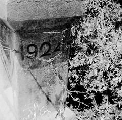
I was not particularly impressed by this trailhead, to be honest.  The trail starts off basically as a road, which means lot of joggers, bicyclists, power walkers, etc.  Of course, I have no problem with others that use these parks – none at all.  But it isn’t really a trail for quite some time.  The first photo here is of a post on a little bridge that makes up part of the path.  Again, it’s more than just a trail at the outset.

There are also a barn right when one gets onto the beginning of this trail, with at least one old, rusted out car abandoned there.  It’s not from 1924 – it’s an old VW Beetle.  But it’s still kind of cool. 

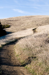
Eventually, however, the trail does appear. I don’t know exactly the combination of paths I took, but I know I ended up on the Guadalupe Trail at one point.  This is a relatively flat path but it’s also out in the open, meaning that it’s hot and really tires you out if it’s sunny.  It’s not a particularly scenic route, either, though it has its moments.  

along the trail

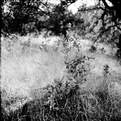
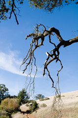
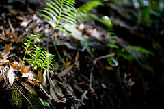
This second photo was taken somewhere along the trail.  I believe towards the beginning, before it opens out into the sun.  That part of the hike is pretty well covered, with nice foliage, big trees that hang over the path and provides pretty nice shade.  I am fairly certain this is the Senador Mine trail.  

I might go back just to try and remember what trails I took…

Review: Monte Bello Open Space Preserve

fingersLast weekend, I went on an “exploratory” hike in the Monte Bello Open Space Preserve, which is located between Rancho San Antonio, Skyline Open Space Preserve, and Upper Stevens Creek Park.  It’s basically straight west on Page Mill Road, well past 280 and almost to Skyline.  Windy road, and lots of fun if your car’s suspension can take it.  This park is also part of the Mid-Peninsula Open Space Preserve, which is a large collection of parks in that area.  There is a flickr group for it, though it’s not very active.

I say exploratory because I really was going in for just a short, 4-5 mile hike to see what the place was like.  How shaded, what kind of foliage was there, etc.  I also went relatively late in the day – about 2.5 hours before sunset – so just looking around was about the most I could do.  You can get a PDF map of the park if you want to follow along with my review.

As always, I planned a route and managed to take a different one anyway.  It was not quite the featured hike from the bahiker.com link above, but my goal was to take the Stevens Creek Nature Trail just to the White Oak trail and be back.  That would be only about 3 miles or so.  However, I got a bit waylaid and turned onto the CAnyon trail rather than making the right onto Stevens Creek.  I eventually looped back onto the Stevens Creek Trail and back to the parking lot.

The signage in the park is really quite confusing – I honestly could not figure out which junction I was at most of the time.  I also managed to sprain my ankle when I thought I was about halfway, which made me keep going.  Turns out I was about 1/4 of the way, and should have just turned around…

The park is a very nice place to hike.  Bikes are allowed on many of the trails but no horses for the most part, and it wasn’t very crowded even for a Saturday afternoon.  You walk in and out of tree cover so it’s not a hike exposed to the sun.  Also, Stevens Creek is just a trickle now but apparently moves quite a bit of water in the winter and that all feeds into a great big bloom of wildflowers in the spring.  Even now, in late November, there was decent greenery and some small amount of flowers about.tiny

The trails can be a bit narrow the path often takenas one walks around and you have to make way especially if a bike comes around, but they are more than manageable and in a way it’s part of the park’s charm.  It’s not that crowded (perhaps the windy road dissuades some people) so the trails aren’t huge, nor are there tons of trails that lead off into nowhere.

I will be visiting it again soon.

Review: Calero County Park, Los Cerritos Trail, McKean Rd entrance

This afternoon I decided to try a new park and went to Calero County Park, in San Jose.  It’s about 30 minutes south of my home in Santa Clara to the entrance just a bit past the intersection of McKean and Bailey Roads.  Unlike most of the parks in the area, Calero is equestrian and hiking only – no bikes – which means it’s pretty quiet, and you don’t run into a lot of people whizzing by.  It’s also probably why it’s simply not as crowded, even on a nice Sunday.  Since the quiet is a big part of why I like to go hiking, I thought this might be a good start.

(more…)